
Customer story: Reducing risk along tunnel corridors in planning phase
Project Background
Nye Veier received assistance from Emerald Geomodelling before designing and building tunnels for the new rv.4 highway along the west-coast of Norway’s largest lake Mjøsa.
The new 20-kilometer road between Gjøvik and Mjøsbrua will improve living and working conditions in the area by reducing travel time and enhancing traffic safety. The current road has a 70 % higher rate of serious accidents including head-on collisions and is thus prioritized for development. Nye Veier is responsible for the project and Norconsult is the consulting engineer for the planning assignment. The planning work started in 2025. A key geotechnical challenge for the project is to identify the ideal placement of a tunnel under the regional city of Gjøvik where only very limited ground investigation data is available in the early phase of the project.
The EMerald Geomodelling team was brought into the project in close partnership with SkyTEM Surveys of Denmark following a joint development project resulting in a new generation geoscanner, perfectly suited for the semi-urban environment of the tunnel planning project
How it was done
For the first time in Norway a new-generation high-resolution Geoscanning sensor, the SkyTEM Diamond system was deployed using a small helicopter able to fly slow and low in areas close to and surrounded by dense population. Three critical areas for the planned tunnels, totalling 2.7 square kilometres, were covered in three days of flying.
While geophysical data were processed by specialists at SkyTEM, the EMerald team prepared the sparse geotechnical data for integration through the EMerald Geomodelling™ ML workflows. To enable efficient planning work, initial ground models were presented to Nye Veier’s engineers five weeks after survey completion. Final models integrated with design-critical analysis were available two months after that including a one-month summer break.
Project timeline
28th May – Geoscanning of 2.7 km2 completed in 3 days
3rd July – Initial ground models presented
July – August – Fill in drillings ongoing
26th August – Final ground models delivered
Deliverables to the customers


Results & Actions
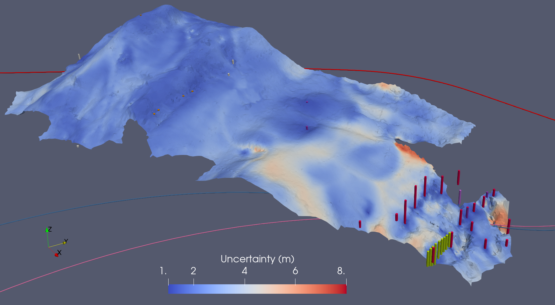
Before geoscanning, the project faced significant uncertainties in ground conditions as only very sparse datapoints from existing and newly drilled geotechnical soundings and samples were available. Choosing a sub-optimal tunnel alignments would have involved significant risks, and potential cost increases later in the project.
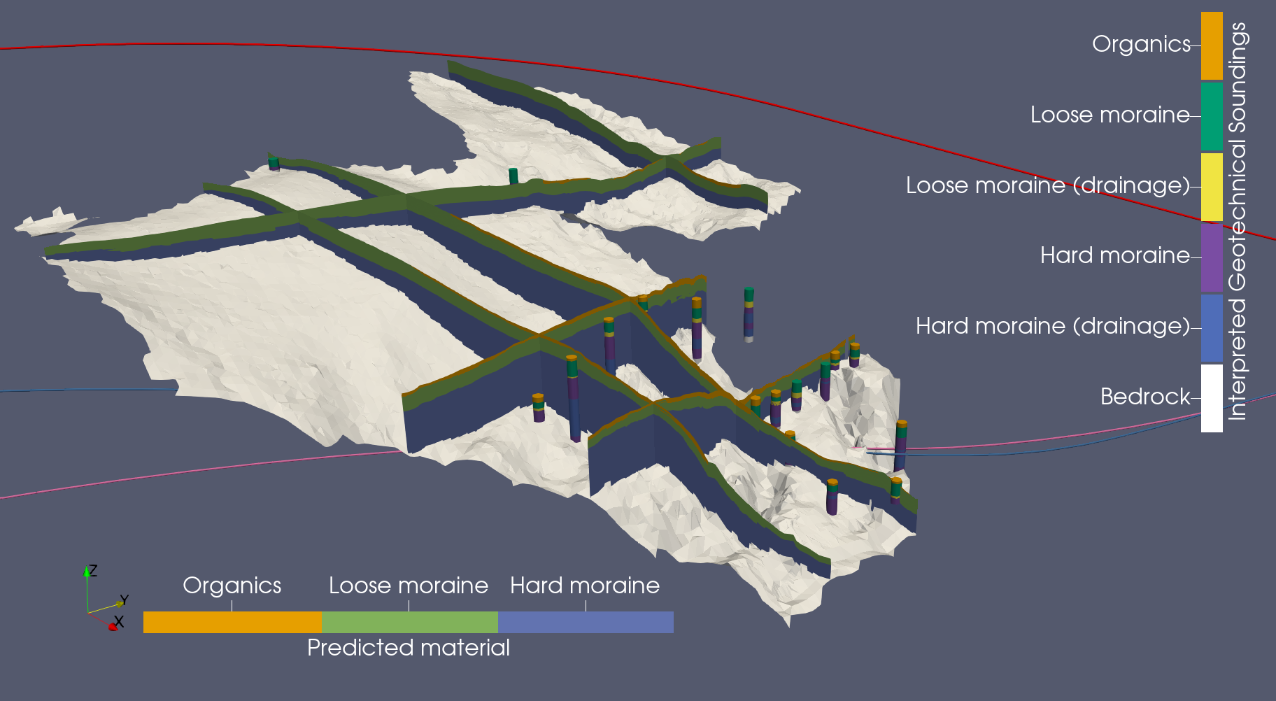
The integrated EMerald ground models provide full coverage and allow for data driven decisions with quantified uncertainty. Whether a tunnel is dug in soil or rock determines costs, resources and construction emissions, these risks are now considerably reduced as tunnel options can be assessed with respect to top of rock surface and existence of black shale units. Critical locations can now be identified and followed up with well-placed soundings and sampling.
Our customers experience
The seamless ground model considerably improved our knowledge and enabled planners to make data driven decisions in terms of route optimization and designing further drilling & testing plans
Highways
Ground modelling in highway construction ensures that roadways are built on solid, stable foundations. It plays a crucial role in the planning phase, enabling efficient route selection and accurate construction cost estimation. By identifying potential subsidence, erosion, or soil instability early on, ground models help prevent long-term damage, costly repairs, or dangerous driving conditions.

Connected resources

Lorem ipsum dolor sit amet, consectetur adipiscing elit. Suspendisse varius enim in eros elementum tristique. Duis cursus, mi quis viverra ornare, eros dolor interdum nulla, ut commodo diam libero vitae erat. Aenean faucibus nibh et justo cursus id rutrum lorem imperdiet. Nunc ut sem vitae risus tristique posuere.
Lorem ipsum dolor sit amet, consectetur adipiscing elit. Suspendisse varius enim in eros elementum tristique. Duis cursus, mi quis viverra ornare, eros dolor interdum nulla, ut commodo diam libero vitae erat. Aenean faucibus nibh et justo cursus id rutrum lorem imperdiet. Nunc ut sem vitae risus tristique posuere.