Geoscanning an Active Construction Site: Handheld scanner Meets Machine Learning in Yokohama
A handheld time-domain electromagnetic (TEM) scanner and a supervised machine-learning workflow were used at an active construction site in Japan, to map a soft clay unit that governs foundation design. In a single field day, two operators acquired data between sheet piles, vehicles and buried utilities. An ensemble of neural networks trained on only two on-site boreholes delivered continuous 3D interface models with quantified uncertainty, pointing to a scalable template for engineering geophysics on infrastructure-dense sites.
Introduction
Geotechnical site characterisation on active construction sites is still dominated by point-based drilling: accurate at the borehole, but spatially sparse, expensive and disruptive to ongoing works. Electromagnetic methods can fill the gaps between boreholes, but have historically relied on point-based, vehicle-borne or airborne platforms that are hard to deploy on a congested live site. A new generation of compact, walking TEM scanners can now acquire data between machinery, stockpiles and temporary works, provided the surrounding workflow can cope with cultural noise and turn sparse soundings into decision-ready ground models.
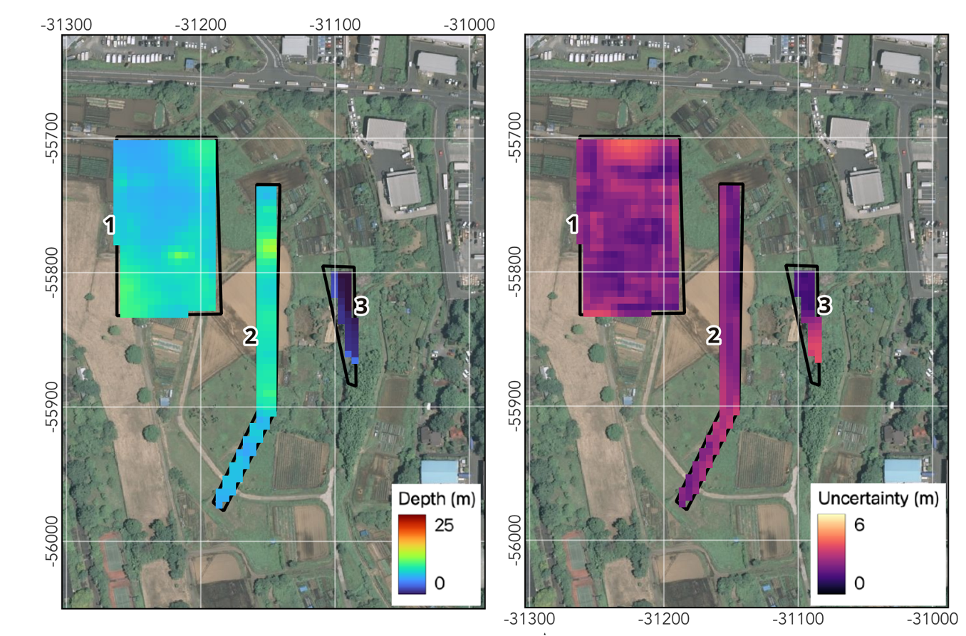
This is phase 1 of a Proof of Concept carried out for Kajima Corporation at a construction site in Yokohama, Japan. The goals were to test whether a handheld TEM scanner can be operated effectively on an infrastructure-dense site, to evaluate the resulting resistivity models against borehole observations, and to show how a machine-learning interface workflow can turn sparse drilling information into continuous, uncertainty-aware geological surfaces. The target was a soft volcanic clay unit overlying coarser silts, sands and gravels. An ensemble of 20–30 neural networks trained on borehole picks and manually interpreted points then predicted the top and base of the clay, with the ensemble spread providing a per-pixel uncertainty estimate.
Conclusion
Predicted interfaces matched the borehole logs, with mean depths of 7.2 m for the top and 16 m for the base of the clay, and average uncertainties of 2.3 m and 3.1 m. At one borehole the resistivity model placed the top of clay deeper than the original geotechnical pick. Closer inspection of the log revealed coarser interbedded material, so the geophysics prompted a refinement of the drilling interpretation, not the other way around.
The survey also defined the method's operating envelope. Where sheet piles, vehicles, fences or buried utilities lay within roughly ten metres of the survey line, the deeper response was dominated by inductive coupling. The shallow response stayed usable, but one area was too strongly affected for geological interpretation. Because weaker contrasts and poorer resolution at depth show up as higher ensemble uncertainty rather than hidden bias, the workflow makes its own limits visible.
The natural role of this approach is not to replace boreholes, but to optimise where they go. It gives geotechnical engineers an early, low-disturbance image of the subsurface, and every new borehole can be fed back into the model as additional training data. Phase 2 will scale up acquisition coverage, add volumetric ML classification of lithology probabilities, and deliver the models directly into the end user's engineering workflows.
Published at the Near Surface Geoscience Conference & Exhibition 2026, Greece, 23rd September 2026.
Success Stories
Discover how our clients have leveraged our expertise to improve their projects, overcoming challenges and achieving success through innovative ground modelling solutions.

Our Solutions
We follow a structured process for geological assessments, from initial data collection to 3D modelling and interpretation, ensuring accurate analysis. Our flexible timelines and customized solutions adapt to project-specific challenges, delivering insights for infrastructure development.